3.04.2014

Leveraged Density: The Rebuilding of Civic Space in the Center of Philadelphia


Benjamin Monette, RLA, ASLA, LEED AP, Senior Landscape Architect, OLIN will be presenting his lecture, Leveraged Density:  The Rebuilding of Civic Space in the Center of Philadelphia on Friday, March 7, 2014 at the 11th Annual Urban Design Conference.  The conference is being hosted by the NC State University College of Design in conjunction with the Department of City Planning, Urban Design Center and NC State Foundation and held at the Raleigh Marriott City Center and lasts from 8:00 AM to 5:00 PM.  Benjamin's talk will beginning at 10:15 and an abstract of that talk is below:

The City of Philadelphia is a city on the mend. Of the Northeastern Cities that have suffered greatly in the waning of the industrial revolution, it has, on the heels of successes achieved in New York and Washington DC, begun its ascension. Dilworth Plaza is but one of many physical and cultural shifts that is reflective of Philadelphia’s growth and in this reflection, compounds the trend. The plaza holds a prominent position West of City Hall at the center of the city. It is being transformed from an inaccessible, multi-level, unattractive, hard-surface plaza into a sustainable, well-maintained, green public space with no stairs or barriers from the street. This presentation will cover the history of the plaza, the concepts embedded in its re-creation as a vibrant social space in a dense city, as well as many detailed aspects of its current redesign and construction. It will include information on stormwater capture, public art collaboration, fountain design, and the latest in parametric modeling and milling of site furniture. The lessons learned from properly scaled design interventions, public art, and design collaboration–a collective intelligence if you will–are transferable to the issues surrounding the densification of the Mid-South Region.

Approved for 7 contact hours: AIA/CES HSW, NCBOLA #9861 and APA #e.26134. Additionally seeking LEED GBCI credit.

Keynote Speakers:

Ignacio Bunster-Ossa, FASLA, | Green Infrastructure
Principal, WRT Design

Julie Campoli | Neighborhood Design
Author, Made for Walking: Density and Neighborhood Design

John Kane, | Mixed Income/Mixed Use
Chairman and CEO, Kane Realty

Joseph Kott, PhD, AICP, PTP | Transportation
President, Kott Planning Consultants, LLC

Mike Lydon | Tactical Urbanism
Principal, The Street Plans Collaborative

Follow @UrbanDesignNCSU
And register here:  http://design.ncsu.edu/urban/registration-form/

2.18.2014

Northlandz


True this is a Sony commercial...but what Bruce Zaccagnino imagined into life is such an colossal work of art, that we could not resist sharing. Northlandz is a 52,000 square foot museum that houses over 100 model trains and their respective tiny tableaux, located off the beaten path in Flemington, NJ. The inventor/artist Zaccagnino first started building trains in his basement, and from there built a truly amazing collection of highly detailed and MASSIVE models.  Enjoy.


2.06.2014

Integrating Natural Processes into the City Fabric of the Global American South


We are excited to announce that on Saturday February 22 at 2:30 Emily McCoy, Kofi Boone and Ben Monette will be presenting on the topic: Integrating Natural Processes into the City Fabric of the Global American South at the Cities, Rivers, and Cultures of Change: Rethinking and Restoring the Environments of the Global American South Conference.  The conference is presented by UNC Center for Global Initiatives on Friday, February 21, 2014 at 2:00 PM - Saturday, February 22, 2014 at 6:00 PM (EST), in Chapel Hill, NC.  Emily, Ben, and Kofi will be presenting in the Nelson Mandela Auditorium on UNC Chapel Hill's campus.

You can register here:
https://www.eventbrite.com/e/cities-rivers-and-cultures-of-change-rethinking-and-restoring-the-environments-of-the-global-registration-10017912847

Below is an abstract of their presentation...we hope to see you all there!


"Urban growth structures and patterns in the Global South are influenced by any number of interconnected macro and micro pressures, functions, and changes.  While a vast swath of the southeast, and to some extent the southwest, continue to undergo rapid growth, a subset of cities in the northeast (primarily the rustbelt cities) have experienced, and continue to experience, a significant decline in population.

In many rust-belt cities, vacant and abandoned structures, polluted post industrial sites, decaying above ground infrastructure, shrinking tax bases, and a combined water and sewer system contribute to a cycle of urban atrophy.  These cities are engaged in a life and death struggle where urban planners, legislators, business owners, and citizens fight for the survival their communities.  To that end, there are creative, adaptive solutions that build on existing strengths and look to leverage government mandates for positive growth.

Among these strategies is a move towards green infrastructure.  In an adaptation of the EPA’s definition, green infrastructure can be described as a storm water management approach that uses vegetation, soils, and natural or engineered processes to manage water and create healthier urban environments4.

Research is currently underway to test, in particular, the engineered systems so that we can build a greener city in a quantifiable and rational manner.  By taking a holistic approach to post occupancy evaluation of green infrastructure sites in cities like Philadelphia PA, we can begin to examine efficacy of both the physical as well as the social performance of these places.  The interplay of functional systems with social use is the true bellwether for how we determine success or failure.

The thin line between these designations when viewed from a visitor, citizen, or neighbor’s perspective can shift and perhaps fray under the weight of social equity and economic reality.  Even if we can dream a plan to life, and get it to function according to design, we continually ask ourselves: are we ignoring the fair treatment of all citizens?  Does everyone enjoy equal access to open space, protection from health hazards?  Is every citizen, regardless of race, ethnicity, or income level able to participate in decision making processes?

These questions of environmental justice provide the final thread to the urban growth dynamic.   Its impacts are relevant across scales of humankind and are the meter with which we must test our planning and design efforts if our goal is to construct a healthier and more diverse future. Looking across these scales and into the “interstices of cities”1 to provide meaningful canvasses for ecosystem services and stages for cultural narratives, we present conceptual, in-progress, and built case studies that marry natural resource management with community building efforts. These studies not only assist communities in-need, but provide opportunity for a place to “adapt to what already existed.”2

What is clear from these studies is that enacting strategies to improve urban life can no longer be encapsulated into one discipline’s goals, one realm of implementation, one type of people, or viewed from one scale3. The leveraging of opportunities in an effort to facilitate sustainable development within the urban form, design and planning strategies must involve the equal pursuance of social, economical and environmental viability with thoughtful attention to qualitative detail."


WORKS CITED
1 Leslie Jones Sauer. The Once and Future Forest: A Guide to Forest Restoration Strategies. (Washington, DC: Island Press, 1998).

2  Rem Koolhaus. “Toward the Contemporary City”. Theorizing a New Agenda for Architecture. (New York, NY Princeton Architectural Press, 1996)

3  Anne Whiston Spirn, “Restoring Mill Creek: Landscape Literacy, Environmental Justice and City Planning and Design, Landscape Research, v.30 no.5, 393‐413, July 2005

4 EPA Website. “What is Green Infrastructure” http://water.epa.gov/infrastructure/greeninfrastructure/gi_what.cfm

1.22.2014

Allan Savory: How to fight desertification and reverse climate change | Video on TED.com


 Grazing, not burning to restore grasslands. Interesting TED talk about holistic management and planned grazing to restore grasslands in Africa by mimicking nature.

Allan Savory: How to fight desertification and reverse climate change | Video on TED.com:

'via Blog this'

1.14.2014

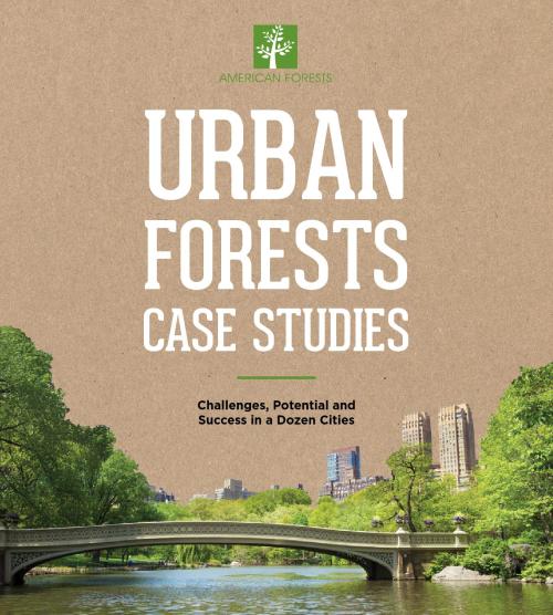
Urban Forest Case Studies: Challenges, Potential and Success in a Dozen Cities

Philadelphia featured in the USDA’s publication, Urban Forest Case Studies: Challenges, Potential and Success in a Dozen Cities

This publication represents extensive research, interviews and examinations into 12 cities that have begun — or are continuing — to make an investment in their urban forests in order to reap future gains.


1.03.2014

The Eye of Sauron? Réservoir Manicouagan


I spy a circular-looking water body that looks almost like a ring, or maybe a flaming eyeball (maybe the Eye of Sauron?!) or perhaps an extremely large moat around the grandest of castles. Could it be a river or a lake? Is it Earthly? What is this un-natural looking ring of water?

Photo courtesy of http://brlndoblog.blogspot.com
Photo courtesy of NASA

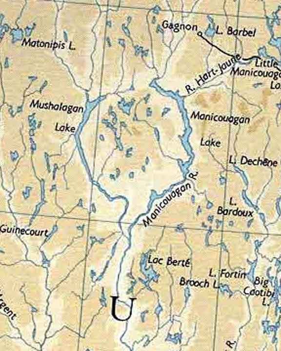
While virtually roaming the New York North Country and Quebec via Google Maps; I spotted a peculiar, circular waterbody with a land mass in the middle...or was it spotting me? This "eye of Quebec" is called  Lac Manicouagan, which surrounds a body of land known as René-Levassuer Island. The island is home to 2 reserves-- Réserve de biodiversité de la Météorite and Réserve écologique Louis-Babel. Before the area was dammed in the 1960's, the water body was actually 2 water bodies-- Lac Mouchalagane to the west and Lac Manicouagan to the east.

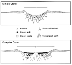
So, what formed the two odd lakes side by side? As one of the "Seven Wonders of Canada," this now one waterbody is known as an annular lake or moat 1, which is a lake formed from a meteor impact and also called an astrobleme. When meteors have such a dramatic impact, they form complex craters with multiple rings, where the middle of the impact uplifts and creates a land mass similar to Manicouagan's. The 60-mile wide impact was so intense, the molten rock took thousands of years to cool (between 1,500 - 5,000 years) 3. The crater is thought to be 213-215 million years old and may have been a part of a multiple impact event, as it forms a theoretical line on the late Triassic continents of North America and Eurasia with other craters, such as Red Wing Crater in North Dakota and Rochechouart Crater in France 4. Interestingly, because of its unique geology, it is considered as a useful analog of other impact structures on other planets, such as Noachian Mars, for space exploration and study 8.


1962 Map of the Lakes before "Damnation" 1

The reserve today 2

Diagram courtesy of Wikipedia  4


 Earth 214 Myr ago,  showing the locations of the five impact structures. 6 

  
The uplifted region-- Mount Babel and its island, Rene-Levasseur Island-- is not only geologically interesting and the second largest lake island in the world, it has a wealth of biodiversity due to its quick transition from the boreal forest to tundra. The reservoir and island are located in the Boreal Shield ecozone and the Central Laurentians ecoregion 9. The rugged terrain hosts species from the boreal ecosystems, which are dominated by black spruce, fir, alder, jack pine, sphagnum and architectural sightings of krummholz; and tundra communities dominated by lichens and blueberries. 91% of the forest stands on the island are older than 100 years and the island houses almost 1,651 hectares of peatland 4,5. Protected peatlands are scarce, as only 3.5% of Quebec's peatlands are protected 5. Moose and caribou are common on the island.  Atlantic salmon, lake trout and northern pike can be found in the reservoir 1.

    
 Impact melt cliff  of the central peak island. 3
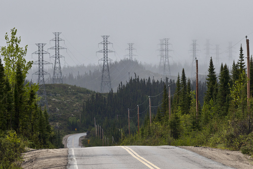
In the 1960's the lake was dammed for hydroelectric power and now supplies power all the way down to New England. The height of the dam is 214 m and some research suggests that the magnitude of the dams in this region have induced seismic activity 10. The lake gets the lowest during the heat of the summer, when New Englanders turn on thier AC's. Wikipedia reports that the chief engineer for the dam, Rene Levasseur, and Dan Johnson, the Premier responsible for the project, both died young from heart problems. Apparently, the native Innu believe that just as the men clogged the rivers, the Earth's veins and arteries, the creator responded by clogging theirs, a belief which could reflect the cultural conflicts of the region. However, this may simply be a rumor, since Wikipedia has no source for this statement. However, there are reports of several conflicts between the native communities and the energy companies. Nonetheless, it fits well into the story of Tolkien's evil eye, the Eye of Sauron....my precious!

A non-profit group, SOS Levasseur acts to protect the unique ecological and cultural resources of the island from destructive activities such as logging and mining, and performs research on the island. Another organization which encompasses all the reserves in the area is called Réserve de la biosphère Manicouagan-Uapishka, designated by UNESCO in 2007. We can't help but wonder what this place would be like if the dam were never built or the logging never occurred. Réservoir Manicouagan looks like a fascinating place to visit and we just might have to add it to the bucket list!


Dams within the Manicouagan-Outardes complex. 10

Manic 5, Daniel Johnson dam. Photo courtesy of http://i.imgur.com

Power transmission along Highway 389. Photo courtesy of http://alavigne.net


Blueberry in a lichen in nearby Mondiale Reserve. 
Photo courtesy of Louis Laliberté

Innu folks fishing. Photo courtesy of Photo Lorcan Otway 1994.
Deforestation on the island. Photo courtesy of Greenpeace.

Ancient forest of the island 7


Vegetation found on the island by SOS 7
If anyone knows this species, please let us know!


http://www.staff.science.uu.nl
2 Gouvernement du Québec, 2009. Réserve de biodiversité de la Météorite – Conservation Plan. Québec, Ministère du Développement durable, de l’Environnement et des Parcs, Direction du patrimoine écologique et des parcs. 24 pages.
4 Wikipedia
686672 (1998): 171-173.
Spray, John G., Lucy M. Thompson, Marc B. Biren, and Catherine O’Connell-Cooper. "The Manicouagan impact structure as a terrestrial analogue site for lunar and martian planetary science." Planetary and Space Science 58, no. 4 (2010): 538-551.
9 Ecological Stratification Working Group, 1996. A National Ecological Framework for Canada. Agriculture and Agri-Food Canada, Research Branch, Centre for Land and Biological Resources Research, and Environment Canada, State of the Environment Directorate, Ecozone Analysis Branch, Ottawa/ Hull. Report and national map at 1:7 500 000 scale.
10 Leblanc, Gabriel, and F. Anglin. "Induced seismicity at the Manic 3 reservoir, Quebec." Bulletin of the Seismological Society of America 68.5 (1978): 1469-1485.